
Strong to severe thunderstorms possible Monday morning ; Snow possible Monday afternoon
- FirstWARN Tri-Cities Staff

- Mar 14
- 2 min read


A dynamic storm system will impact the region from Sunday evening through Monday, bringing high winds in the mountains, a line of strong to severe storms early Monday morning, and even some snow showers behind the cold front.
Here’s what we’re watching:
High Wind WATCH – Mountains (Sunday Afternoon → Monday Afternoon):
A High Wind Watch has been issued for the mountains of East Tennessee from 2 PM Sunday through 2 PM Monday.
• Sustained winds: 25–40 MPH
• Wind gusts: up to 65 MPH
• Isolated gusts over 75 MPH possible in higher elevations such as Camp Creek
These winds could lead to downed trees and scattered power outages in the mountains.
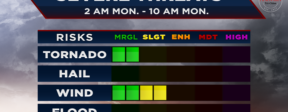
Severe Thunderstorm Risk (2 AM – 10 AM Monday):
The Storm Prediction Center now highlights the entire region in a severe weather risk.
• Most areas are currently in a Level 1/5 (Marginal Risk)
• The National Weather Service in Morristown says a Level 2/5 (Slight Risk) could expand into our area as we get closer.
A strong line of showers with embedded thunderstorms will move west to east between 2 AM and 10 AM Monday.
Main threats:
• Damaging wind gusts
• Heavy downpours
• Isolated spin-up tornado possible
Despite limited instability, very strong wind dynamics could allow storms to bring strong winds down to the surface.
The Storm Prediction Center also notes:
• A low-end risk for significant wind gusts, with isolated gusts over 75 MPH possible in storms
• A very low risk of a strong tornado
Snow & Cold Temperatures (Late Monday):
Behind the cold front, temperatures will quickly drop, allowing rain to transition to snow showers.
• Best chance for accumulation above 3,000 feet
• 1–3 inches possible in the highest elevations
• Valley areas, including the Tri-Cities, may see a dusting on grassy surfaces
Cold air follows the system:
• Freeze likely Monday night and Tuesday night
• Overnight lows could drop into the teens
Prepare Now:
Since storms may arrive while many are asleep, make sure to:
✔️ Have multiple ways to receive weather alerts overnight
✔️ Charge phones and devices in case of power outages
✔️ Know where you will go if a warning is issued for your area
Our team will continue to update the forecast through the weekend and will be LIVE with severe weather coverage if warnings are issued early Monday morning.
Stay weather aware.


Comments