
WEATHER ALERT DAY: Winter Storm Warning issued for Friday and Saturday
- FirstWARN Tri-Cities Staff

- Jan 29
- 1 min read


Friday and Saturday are FirstWARN Tri-Cities Weather Alert Days due to a winter storm expected to bring accumulating snowfall to the region.
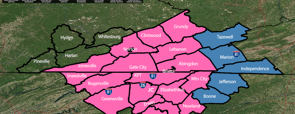
NEW: A Winter Storm Warning has been issued for the Tri-Cities from early Friday afternoon through Saturday night as significant snowfall is likely. The Winter Storm Watch for eastern areas is expected to be upgraded very soon. Either an Advisory or Warning is likely for Southeast Kentucky.
Snow Timing:
Snow will move into far northern areas mid to late Friday morning, then spread south
The Tri-Cities can expect snow to begin between 2–4 PM
A few flurries are possible as early as noon in the metro area
Expected Snowfall:
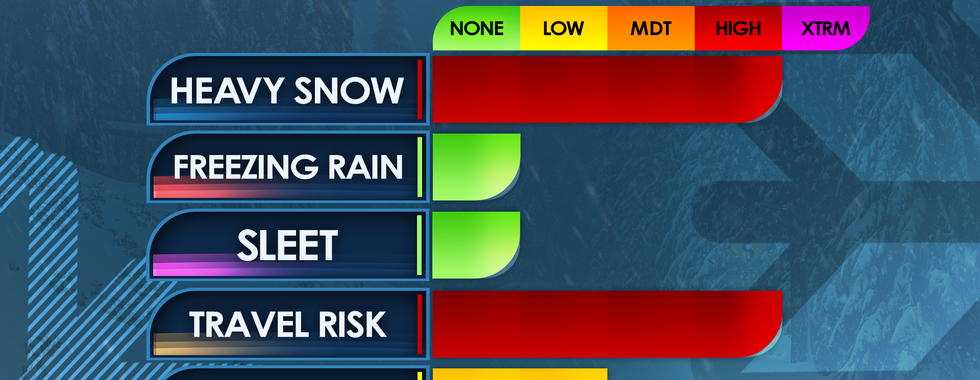
Widespread 3–6 inches for much of the region
2–4 inches in far western areas
6–8 inches possible just east of the Tri-Cities
⚠️ This higher-total zone could expand, so check back for updates
Temperatures:
Highs Saturday: upper teens to near 20°
Highs Sunday: low to mid 20s
Lows Saturday & Sunday nights: single digits
Extremely cold temperatures while snow is falling will allow for higher-than-normal snow ratios, meaning snow can accumulate quickly even with lighter precipitation.
School Impacts:
Many have questions about school plans. Early dismissals are possible, but we will not speculate on individual school systems. A closings post will be pinned to the top of our page.
Stay with FirstWARN Tri-Cities for frequent updates as we continue to track this winter storm closely. Stay weather alert.


Comments