
Freezing Rain Threat Continues to Rise for Saturday Evening & Night
- FirstWARN Tri-Cities Staff

- Jan 22
- 2 min read


The main impact of this significant winter storm is now expected to be freezing rain and ice accumulation. While the region will still see some snowfall, mainly at the beginning and end of the system, the middle portion of the storm is increasingly likely to feature sleet and freezing rain.
As the ice threat increases, so does the risk for power outages across the region.
Alerts Update:
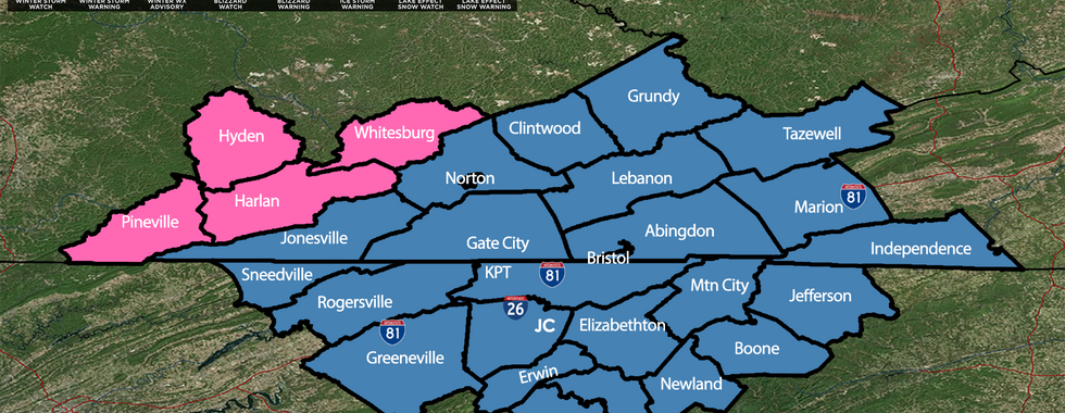
Winter Storm Warnings are now in effect for Eastern Kentucky
Remaining Winter Storm Watches are expected to be upgraded to Winter Storm Warnings or Ice Storm Warnings overnight or early tomorrow
Ice Accumulations:
¼ inch to ½ inch of ice is possible across much of the region
This level of ice is significant and could result in:
Extremely hazardous travel
Downed trees
Widespread and potentially prolonged power outages, especially in hardest-hit areas
Snow Totals Update:
Snow totals have decreased overall, but:
3–6 inches, with isolated 6–8 inch amounts, are still possible in Southwest Virginia
The Tri-Cities could still see 1–3 inches, mainly on the front end and back end of the storm
Freezing rain and sleet are now the primary concern
Storm Timeline (Current Expectation):
Midday Saturday: Snow begins
Saturday evening & night: Transition to sleet and freezing rain
Late Sunday morning: Some areas may briefly change to rain
Sunday evening through Monday afternoon: Snow on the backside of the system
Important Reminder:
A shift in the storm track of just 30–50 miles could significantly change snow and ice totals. We are continuing to monitor all model guidance closely. A temperature difference of just a couple degrees at the surface or in layers of our atmosphere can also change our precipitation type forecast.
Please stay tuned for frequent updates as we move closer to the event and prepare now for dangerous travel and possible power outages.


Comments